The Barrier Islands that protect the mainland
of most of eastern America are indeed a fragile environment. Mans' best efforts
to stabilize them and live there can only be temporary as it is frequently
proven that change is inevitable.
 |
Barrier Islands in general are highly
dynamic, but North Carolina's Barrier Islands are exceptionally so--especially
the islands that make up the Outer Banks and Core Banks. Much of eastern North
America, from New Jersey southward all the way around Florida and then westward
and south again to Mexico, has barrier island ecology characterized by low
sandy islands that are easily affected by wind, tides and currents that protect
the mainland from those forces. What makes North Carolina's islands unique is
their distance from the mainland and their close proximity to the Continental
Shelf and the Gulf Stream current.
Formation of the Islands
As geologic features our islands are relatively young. At
the close of the last ice-age--about 18,000 years ago-- sea levels were about
300 feet lower than today and the climate was considerabley cooler. Boreal
pine/spruce forests similar to those existing today at the highest elevations
of the southern Appalachian mountains, like Mt. Mitchell, reached all the way
to the present coastal plain. Gradual climatalogical warming brought about a
transition to a Hemlock/northern hardwood forest and eventually the Gum/Cypress
forest types that are the climax communities of the wet areas of the coastal
plain today. With a warmer climate came higher sea levels which are continuing
to rise at a rate of about .5' to 1.5' per century. Barrier Islands probably
first appeared as sea levels rose and flooded areas behind beach ridges.
|
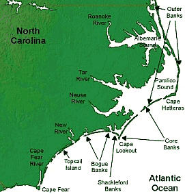
Sediments being washed down through the major river
systems like the Roanoke, Tar, Neuse and Cape Fear rivers continue to feed sand
for the formation of islands and the flow of water that must enter the sea
keeps inlets open. Sand also erodes and accretes primarily from north to south
along the coast as well. Though fragile, the barrier islands seem to have a
mechanism in place to insure their continued existence in some form.
In northeast North Carolina, the land is subsiding
(sinking) independent of sea-level rise, while in southeastern North Carolina
the land is rising. This compound effect seems to be responsible for the
northern islands increased distance from the mainland compared to the southern
areas and is seen illustrated in the character of the river mouths that form
the wide Albemarle and Pamlico Sounds (outlets for the Roanoke, Tar and Neuse
Rivers in the northern part) compared to the Cape Fear River mouth which flows
between substantial cliffs almost until it reaches the ocean, in the
south.
Migration and Movement of Islands
Rising sea-levels and predominant winds from the
northeast cause a landward migration of the islands. During storms, overwash of
the islands by the sea pushes sand to the mainland side in large quantities.
Strong winter winds blowing predominantly from the northeast also pushes sand
towards the land. As a result, dunes intrude into marine forests burying trees
on the western sides of islands, while at the shoreline layers of peat and old
tree stumps become visible. In some parts of the coast layers of shells are
uncovered by eroding shorelines that are many thousands of years old relics of
much earlier ocean inundations of the land. Though these forces have effects
over hundreds and thousands of years, any large storm can bring incredible
changes to the islands in a matter of a few hours. Houses get washed away with
every hurricane and new inlets can form or old ones close. Erosion is
constantly at work and poses threats to any hard structures that are placed on
the beach. We have enough of a historical record to see how dramatic these
changes are even in a relatively short period of time.
These same wind and weather patterns also move sand
generally from north to south. At natural inlets sand tends to erode from the
north and accrete (accumulate) on the south side. Where man puts hardened
structures like jetties or groins in place, the opposite is true-- sand blocked
on its normal southerly migration piles up on the north side of a jetty but is
eaten away on the south side by the eddy that is created.
The physical nature of many of the Barrier Islands has
been altered by man in the 20th century. Beach dunes are often man-made
structures, first constructed by the Civilian Conservation Corp in the 1930's
as erosion control measures and needing regular maintenence to keep them in
place and protect roads and property. The natural form of many of the islands
is a much more flattened form that is more susceptable to overwash and movement
in general. Inlets especially require a lot of attention and must be
artificially maintained with dredging and pumping sand to depleted areas to
maintain shipping channels.
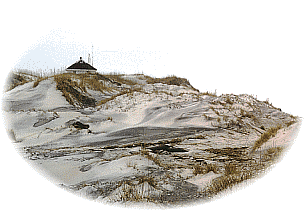
Not all dunes are man-made of course. Notable examples of
natural dune structures occur at Kitty Hawk and Nags Head, NC and at Carolina
Beach State Park, below Wilmington, NC. The highest dunes like Kill Devil Hill
and Jockey's Ridge seem to exist due to a combination of factors generally
relating to the islands orientation to the prevailing wind fields. Strong
winter winds from the northeast push sand to the southwest, while summertime
winds which aren't as strong push it back to the northeast gradually increasing
the height of the dunes. The greater strength of winter winds causes dune
migration to the southwest.
Summer hurricanes and winter storms called "Nor'
Easters" account for the most dramatic short-term changes to the islands.
A large hurricane can overwash large areas of the islands causing millions or
even billions of dollars in property damage and loss of life. New inlets can be
created and old ones closed as has happened on many occassions. Salt water
intrusion into marshes can cause full-scale die-offs of some of the local
flora. The man-made dune structures have proven very effective in lessening the
damaging effects of storms and have helped make it possible to live on the
Barrier Islands. The height of the dunes keeps the entire island from being
overwashed, but breaks in the dunes allow the irresisitable force of water
through.
A quick look at the map shows that Cape Hatteras is
situated well out to sea. It is in fact only about 40 miles to the Continental
Shelf and the Gulf Stream current. The Gulf Stream acts as a conduit for
tropical weather systems like hurricanes to move north and the proximity to the
deep waters beyond the Continental Shelf create very turbulent waters.
The forces of nature truly prevail in the Barrier Islands
and our presence there is allowed by grace. Try as we might to protect our
property and to manage these dynamic systems, our efforts can only postpone the
inevitable when nature has other plans. We must be accepting of the fact that
the islands exist today, but may change dramatically tomorrow.
©
1995-2002 NCNatural, Last updated