
| WEATHER | | | CALENDARS | | | ADVENTURES | | | TRAVELS | | | MUSIC | | | COUPONS | | | BOOKS | |||||||
|
Pisgah National
Forest - Appalachian/Toecane
Ranger District
Elisha Mitchell and the Black Mountains of North Carolina
|
|||||||||||||||||||
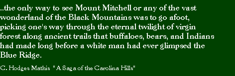
Since the time of the first people of this continent, the area known now as the Black Mountains has been a serene and spiritual place. The mountains sweep up dramatically from the Cane and Toe river valleys often losing themselves in the clouds 3,500-4,000 feet above. In the bright light of noon, the high peaks and ridges are a dark dark green, nearly black. The Balsam forests of these high ridges are reminders of a colder time long ago, echoes of the last ice age. Before the pollution and haze of our times limited our view, the high mountain offered breathtaking clear panoramas of a distant wild landscape. On a clear day the peaks of Grandfather, Roan, Tablerock, Hawksbill, are visible easily. The Craggy Mountains are nearby, and the Smokies 75 miles distant form the sunset horizon.
The deep coniferous forest is more like those of eastern Canada than the nearby slopes of the Blue Ridge, several thousand feet below. The forest is a remnant of the ancient woods of North America which covered the continent some 200 million years ago. In that time the mountains were thousands of feet higher and the forest even blacker. That deep forest remained undisturbed for millenia, until the first white settlers began carving out homesteads and releasing livestock into the foothills and valleys in the early 19th century.
It is thought that the region was inhabited by early Eastern Woodland Indian cultures as early as 15,000 years ago. An archaeological site on the campus of nearby Warren Wilson College contains evidence of cultures dating as far back as 5,000 BC. When the first white explorers came to the region in the seventeenth century the Cherokee homeland was well established. In fact, the current route of I-40 follows closely an important Indian trail that crossed the Blue Ridge at Swannanoa Gap, the Suw'li-nunnu' (-hi) or Suwali Trail.
Early Exploration
Before the mountains were settled, men like John Bartram and Mark Catesby were
exploring the region and finding a wonderous wild world, full of danger and
opportunity. The regions rich flora and fauna were the primary motivator of
the early explorers, but trading with the Indians soon brought more settlers
to the region. As more and more whites moved into the region, the relationship
with the Cherokee deteriorated, and by the 1760s it was quite poor. Efforts
by the British to establish the Black Mountains as a boundary were futile, and
settlers continued to move into the area. A treaty signed in 1777 officially
delineated the boundary of settlement along a line that followed the Black Mountains
from Yeates Knob to Potato Knob. This opened up the valleys of the Toe and Cane
rivers to settlement by the whites. Throughout the early 1800s the pioneer families
of the region staked out their homesteads and settled into a rugged life in
one of the nations most wild places. Bear and deer were abundent, as were trout
nd turkey. The great mountain man "Big Tom" Wilson killed 114 bear
in his lifetime. No easy task with a musket.
Andre' Michaux names
the Blacks
It was during the late 1700s that leading scientists and explorers began to
study the regions flora and fauna and take an interest in its commercial value.
Mose Ashley Curtis was among the second generation of Black Mountain explorers.
A botanist and plant collector he travelled the mountains collecting plants
and cataloging species. Of even greater reknown was the French botanist Andre'
Michaux He is credited as being the first white man known to have set foot in
the Black Mountains. He travelled in the Carolinas in 1787 with his son Francois
Andre' who was to become a leading botanist himself. Michaux made several trips
to the Carolinas, and in 1789 he made his historic first trip to the Black Mountains.
It was Michaux who first called the mountains by their current name, arriving
at "parties basses de la Montagnes Noire" (the lower portions of the
Black Mountains) on November 25th , 1789. Over the next several days Michaux
collected over 2,500 specimens of trees, shrubs, and other plants. It is uknown
whether Michaux ever ascended to the crest of the Black Mountains.
Elisha Mitchell and
The Black Mountains
It was scientific exploration which was responsible for making the mountains
known outside the region. And while botany was the primary motivation for the
first scientists, it was physical geography and geology that brought the regions
most famous scientist to the Black Mountains. Elisha Mitchell came to the Blacks
as a part of the North Carolina Geologic Survey in 1825. While working with
the survey in 1827 and 1828 Mitchell made his first trips west of the Blue Ridge.
Mitchell was well known for his extensive knowledge in a number of fields, and
he was one of North Carolinas great scholars. In 1827, he first saw the Blacks
and commented even then that they seemed higher than Grandfather Mountain, which
was then regarded as the highest peak in the region.The next year he climbed
Grandfather to better compare the two elevations. He was certain enough that
the Black Mountains were higher that he noted in an 1829 geologic report that
he felt the Blacks were the hishest peaks between the Gulf of Mexico and the
White Mountains of New Hampshire.
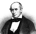
In 1835 Mitchell returned to the Blacks to measure their peaks and ascertain whether they were truly the highest. The trip was the first of many, and later a great controversy would develop over whether Mitchell had ever been to the highest peak in the Blacks. With no maps and only local guides, finding the high peak and then climbing and measuring its height was quite a challenge. It is a testament to the strength of Mitchell that he was able to cover so much of the Blacks during his explorations. To determine which was the highest peak, Mitchell would climb nearby peaks and ridges and spot over to the main ridge of the Blacks. Then he would descend into the Cane River valley and the next day he would go up the steep ridge with a local guide, trying to end up at the same summit he had seen from a distance the day before. Even today with maps and trails, it would be an impressive achievment. Such a hike entails covering close to 40 miles in two or three days, and involves climbing from 2,500 ft. up to a ridge line at 5,800. Then back down into the valley and up to 6,600 ft the next day. Considering that much of the higher elevations were covered with incredibly dense laurel thickets, and inhabited by snakes and bears, it is a wonder he ever made it up the first time. His account of the first trip to the ridge crest includes a description of the agony of crawling several miles along bear trails in the dense laurel, unable to stand up at all.
His 1835 trip included the peaks of Roan Mountain, Grandfather, Table Rock, Celo Knob, and Yeates Knob, then finally up the steep slopes of Mitchell itself. His determination and conditioning are certainly to be admired. The trip up and down Mitchell covered an estimated 18 miles and an elevation change of 3,800 ft. It is no wonder that the professor admitted being "thoroughly fatigued" at day's end. While on the high peak, Mitchell measured the temperature and barometric pressure, readings which later enabled him to determine the height of the high peak as 6,476 ft. Thus Elisha Mitchell had made his greatest accomplishment, demonstrating scientifically that the crest of the Black Mountains was the highest point in the United States measured at that time.
Historical note - I use the current names of the mountains to avoid confusion - but in the 1840s and 1850s, current Mt. Gibbs was known as Mt. Mitchell, and Clingmans Peak was the current Mt. Mitchell. Later, Clingmans Peak became what is today known as Mt. Gibbs, Mt. Mitchell became the true high peak, and Clingmans name was given to a mountain in the Smokies. It is all very confusing and even I sometimes have trouble understanding which mountain is which while reading through the histories. If you travel to Mt. Mitchell today, you will note that Mt. Gibbs - Potatoe Top is where the radio tower is located, south of the observation tower.
Mitchell's Explorations
Continue
On subsequent trips to the Black Mountains in 1838 and 1844, Mitchell climbed
to the high ridge from the direction of Dillingham's Cove, in the vicinity of
present day Barnardsville . Climbing the ridge from this direction Mitchell
and his guides ended up on what is now known as Mt. Gibbs - Potatoe Top. He
took readings which were used to determine the elevation and calculated the
height to be over 6,600 ft. This error would eventually cost Mitchell his life,
as he now claimed that the peak he climbed in 1835 was not the highest (though
we are most certain today that it was). By changing his mind about the location
of the highest peak, Mitchell opened the door for another explorer to come in
and take claim to discovery of the highest peak.
Throughout the late 1840s travel up the mountains to the ridge crest increased and several trails were established by the early 1850s. But the traffic only went so far as Mt. Gibbs in the southern end of the mountains. This was the area mistakenly identified by Mitchell as the location of the high peak in 1844. As travel up the mountain continued to increase, a tourist industry sprang up and several inns were established along the route. William Patton, a wealthy merchant from Charleston, South Carolina purchased nearly 5,000 acres of the mountains in the late 1840s and established several homes and lodges. At that same time David L. Swain also purchased considerable acreage (nearly 13,000 acres) in the Cane River valley. In 1851 Patton extended a horse trail up the slopes of the mountains to the high peaks in the south. The now easy access to the peaks of the Blacks which brought in a new wave of scientists and explorers. Among them were the famous geologist Arnould Guyot and United States Congressman Thomas L. Clingman.
 A Controversy over the High Peak
In the mid 1850s the high peak of the region was considered to be the current
Mt. Gibbs, several miles south of Mt. Mitchell. On September 8th, 1855, Clingman
ascended the Black Mountains and measured the height of Mt. Gibbs. He then continued
on to Mt. Mitchell and measured the height there. He was surprised to discover
that Mt. Mitchell was the higher of the two. He immediately claimed to be discoverer
of the high peak and published his claim. Upon reading Clingman's claim, Mitchell
was determined to defend his own discovery, and the ensuing controversy ultimately
cost Mitchell his life. By this time Mitchell was 62 years old, and his memories
of the 1838 and 1844 trips to the region were less than clear. As a result,
Clingman was able to use Mitchells own accounts to discredit him and it seemed
for a time that he would win the honor of being the "discoverer" of
the high peak. To defend his claims, Mitchell made several trips to the Blacks
in hopes of retracing his route up to the summit and re-establishing his claim.
The Final Journey of
Elisha Mitchell
During an 1856 trip to the region, Mitchell was unable to clear up any of the
uncertainty of his early claims to discovery of the high peak, so he returned
to the Cane River valley in 1857 for what would be his final effort. There are
several versions of Elisha Mitchell's last walk in the Black Mountains, but
all versions must agree on the ending. On June 27, 1857 at approximately 8:19
PM Elisha Mitchell slipped on a rocky ledge above a 20
ft waterfall (Mitchell Falls) and fell to his death. He hit his head as
he fell and drowned in the deep cold pool below. Mitchell had hiked to the top
of the ridge where he had been in 1835, on the high peak itself, and had become
lost on his return from the top. He went down a dangerous steep ridge and when
darkness began to overtake him he went down off the ridge and started traveling
the creek bed. There were no trails, and the terrain is rugged and dangerous,
with frequent drop-offs of 20-60 ft. While trying to cross the creek he slipped
and fell to his death. It was many days before his body was found by Big Tim
WIlson, a noted tracker and hunter who was familiar with the area and had tracked
Mitchell's final journey back down the mountain from where he had left the ridge.
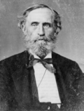
The Story is Told
Perhaps the best account is given in a story by C. Hodge Mathes called "A
Saga of the Carolina Hills." The story is a recounting of the original
events as told to him by Dolph Wilson, son of Big Tom Wilson. The story was
recently published in a beautiful book called "In the Spirit of Adventure
- A 1915 Mount Mitchell Hiking Journal", written by D.R. Beeson . C. Hodge
Mathis was Mr. Beeson's hiking partner during those trips and it was then that
they had the opportunity to meet and hike with Big Tom's son Dolph, by then
a famous mountain man himself. I highly recommend the book. It is an incredible
trip back in time, with wonderful black and white photography of the wild mountains
in 1915. This was during the peak of the destructive clear-cutting of Mt. Mitchell
and Beeson and Mathis are keen to note the stark contrasts between the wildness
of the Cane River Valley, and the unsightly heavily logged eastern slopes of
the Blacks.
The controversy did not end with Mitchell's death, and it took several years before the high mountain was officially named Mt. Mitchell, and the original Mt. Mitchell became known as Clingman's Peak, though today it is more commonly called Mt. Gibbs - Potatoe Top. The 1881-1882 U.S. Geological Survey upheld his measurement of Black Mountain as the highest peak and officially named it Mount Mitchell. In the 1850s the mountain was just beginning to experience the destructive power of humans, as it soon became a tourist mecca of sorts. But tourist were not the worst to come. In the early 1900s the lumber barons of the northeast, fresh from the clearing of most of their virgin forests descended upon Mt. Mitchell with an awesome destructive fury and nearly cleared the forests off the mountains in less than 20 years. A wilderness that had taken nature thousands of years to shape was nearly wiped out in less than one generation. The story of the logging and eventual saving of Mt. Mitchell is a tale worthy of Part Two of this "brief" web version of Mt. Mitchell's history. It is a tale of villains and heros, and the saga continues even to this day as Mt. Mitchell State park preserves the natural history of the mountain, the National Forest Service manages the northern and eastern portions, and concerned private landowners manage the still vast wilderness of the Cane River Valley, where Elisha began so many of his historic journeys.
There are several accessible hikes for the adventurous who wishes to see the region up close. The Big Butt Trail ,USFS#161, leaves from the Balsam Gap parking area at milepost 359.8 on the Blue Ridge Parkway between Craggy Gardens and Mt. Mitchell State Park. Big Butt is the current day name for Yeates Knob, where Elisha sighted across the Cane River Valley to the highest peak of the Blacks. Standing on Big Butt, one can realize the magnitude of Mitchell's efforts if one considers hiking 3,000 down into the Cane River Valley below, then hiking back up 3,500 ft. to the top of the ridge across the valley. Another great hike is up to the top of Celo Knob, the first peak Mitchell climbed in the Blacks. See NCNatural's National Forest Service pages for complete coverage of all the Appalachian/Toecane Ranger District which encompassses all of the Blacks.
For further study of Elisha Mitchell and the Black Mountains, I recommend:
| *NEW*
Mount Mitchell and the Black Mountains An Environmental History of the Highest Peaks in Eastern America Timothy Silver © 2003 University of North Carolina Press. This book is available on-line at http://uncpress.unc.edu/books/T-1540.html |
| *NEW* Mitchell's Peak, a Novel of Discovery Robert Dellinger A fictional telling of the story of Elisha Mitchell and his triumphs and tragedies on the Appalachians' highest mountain. Visit www.CalebsPress.com |
| A
History of Mt. Mitchell and the Black Mountains Exploration, Development, and Preservation S. Kent Schwarzkopf © 1985 North Carolina Division of Archives and History This book is available from Amazon.com, or at the Forest Service office in Asheville and at the Toecane Ranger District Station in Burnsville. ISBN 0-86526-218-7 |
| In
the Spirit of Adventure A 1915 Mount Mitchell Hiking Journal D.R.Beeson Available from Amazon.com. This book also includes the wonderfull story "A Saga of the Carolina Hills" by C. Hodge Mathes © 1995 Panther Press PO Box 636 Seymour , Tennessee 37865 (423)-579-5792 ISBN 1-887205-00-4 Paperback and 1-887205-01-2 Hardback |
| Mt.
Mitchell Its Railroad & Toll Road Jeff Lovelace Available from Amazon.com © 1994 The Overmountain Press Johnson City , Tennessee ISBN 0-932807-84-4 |
© 1995-2002 NCNatural, Last updated